Monday 27 June 2011

Sent from Dinosaur Colorado

Wednesday 22nd June
We left the campground in the forest quite early to drive to Cortez to try to get a good internet connection so we could phone Steve's Mum at a reasonable time in the UK, on her 91st Birthday. We succeeded and had a really good chat. Unfortunately it was raining there while we were sweltering in Southern Colorado.
After uploading a few more photo's to the album (don't forget to take a look regularly). We continued our journey to "The Needles" which is the southern part of Canyonlands National Park. We stopped at the information center in Monticello just outside the park and spoke to the very helpful gentleman there who told us the best way to see the Needles. He also said we were welcome to fill up with water there because there were no facilities in the park. Apologizing profusely that they had no dumping facilities because when they built the center last year they ran out of money before they could build the "Dump".
We arrived at "Squaw Flats Campground" and luckily took the last spot. Just settling down to prepare dinner and a Lady Ranger came by to invite us to her talk at 8pm. A bit of a rush but we just made it on time. It was very interesting all about Scorpions, Mountain Lions and all the other dangerous animals in the park. It turned out that as usual "Man" was the most dangerous.
Thursday 23rd June

We started quite early to drive along a very tight and windy dirt road which was supposed to be only for vehicles less than 21ft, but we are Europeans and only talk metric so couldn't work that one out could we (grin), we started on our hike only to find that Steve's Achilles Tendon was causing him trouble again. He didn't need the crutches but it limited us to only a mile each way which was a shame. When we got back to the trail-head we found that we had taken the 4x4 trail instead of the hiking one. But it was fun as we had the opportunity of watching a couple of German guys in a hired 4x4 go over the most impossible terrain with 2 to 3 foot boulders. But the Hiking trail was five miles each way so we couldn't have done it anyway. But we got a good view of Elephant rock and the needles in the distance and the snow on the mountains behind us. We decided as hiking was out we would make our way out of the park stopping at all the sights on the way which only involved fairly short walks which Steve could manage. One amazing point which we had heard about was "Newspaper Rock" which was a large flat rock in an overhang which was covered with a coating of "Desert Varnish" the dark staining which is caused by moisture running down the sand stone. Here over many millenia people had chipped away to produce drawings some very detailed and precise except the modern graffiti which some morons had defaced the mural with. It gave the impression of a giant notice board where messages were left perhaps about good hunting or whatever. The strangest was one which looked like a "Space Man" it was very dull so perhaps one of the first but it was about twenty feet up from the ground.
Onwards eventually to Moab visitor center where we found that the Arches campground was about twenty miles into the park and probably wouldn't have any spaces, but along the Green River nearby the ureau of Land Management ground had about twenty campgrounds so as it was late we headed there and found the last pitch on the second one we passed. It was very nice but we discovered that we had no change to be able to put the correct amount into the envelope so had to walk round the site scrounging for change and finally found somebody who had $19 change in exchange for our $20 note so we could stay. Steve then spent the whole evening with ice packs and Voltorol trying to sort his heel out for walking the next day.
Friday 24th June
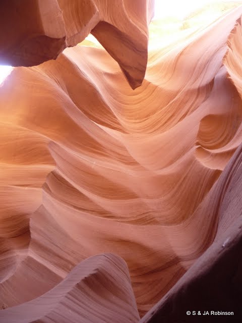
The Arches National Park was only about 15 minutes from our campground in the morning but the visitor center again said there was no room at the campground but we decided to drive the twenty miles in then if there was no room we could work our way out visiting the sites and go back to our campground the next day. But there were a couple of spaces so we paid our dues with the campground host and headed out to try a fairly strenuous hike but if Steve's heel couldn't take it, it was possible to shorten it. But amazingly the ice etc. had worked and he and Judy managed a very strenuous ten miles to see some of the most amazing sandstone arches which involved walking on the top of sandstone "Fins" just a couple of yards wide. The temperature was over 100deg F an both Judy and Steve ran out of water in their Camel-Bak's about 500 yards from the end where thankfully there were water taps to fill up again. So a restful afternoon with more ice treatment and another very interesting Ranger talk this time about venomous creatures in the park, "the kids love it".
Saturday 25th June
A leasurely start then some more very strenuous hiking to see first "Delicate Arch" the most photographed and the one that appears an most brochures and on the Utah car License Plates. The day was even hotter and to get to the arch required climbing up a 45deg slick rock slope over a mile long with no cover at all. The heat was coming from the sun and being reflected straight up again by the rock so the combined heat I am sure was well over the 100 degF, sorry to talk in Imperial measurement but we have had to get used to it here as the Americans do not do Metric. But we have bought an In-Out thermometer so we can see what the max and min is each day. Last night the low was 31degC (88F) and the max today was 44 degC (111F).
After that we worked our way out of the park stopping at many of the overlooks and hiking to see the "Window Arches" which is a collection of about twenty arches in one area. Some quite photogenic ones but many quite hidden with rocks behind them masking the view.
We visited the "Fiery Furnace" a rock formation which appears to glow in a certain light but we were not there at the best time so will just have to believe the brochure.
So after stopping at the visitor center to fill up everything we could with drinking water as we are consuming about a gallon each a day we left the park to camp by the river again. First remembering to get change for the envelope.
Sunday 26th June
There is a canyon walk across the road from the campground so we decided to get up at 6am to walk into "Negro Bill's Canyon" to see the 6th biggest arch in the USA "Morning Glory Arch" The sign said 2½ miles each way and it was a really nice walk beside a cool bubbling river and having to ford the river back and forth on stepping stones about five times. But the arch when we reached it at the end of the canyon was enormous, over 200ft wide and about 90ft high. We arrived back at the campground at 10am so a quick drink and away for a long scenic drive to Dinosaur National Monument. We have decided to skip the 600 mile round trip to Denver and the Rocky Mountain National Monument because we are getting short of time and do not want to miss any of Yellowstone National Park. So another time perhaps.
After a beautiful drive along the Green River then over the mountains we arrived at the town of Dinosaur Colorado and found the Colorado welcome center at about 4:30, we were getting desperate for a "Dump Station" because the last few campgrounds have had no facilities and the nice ladies in the welcome center said there was one provided by the town just across the road, so we sorted out our tanks and took advantage of the free showers also provided for visitors use. The Welcome Center also has wifi which I am using now to send this so a really nice town who welcome visitors. Don't forget to look at the picture gallery to see the pictures of the amazing rock formations in Arches National Park.
Regards, S&J

Wednesday 22 June 2011

Sent from Cortez Colorado

Sunday 12th June
Forgot to mention in our last blog our visit to Horseshoe Bend on Sunday evening before stopping for the night at Wal*Mart, which can best be understood from the pictures in our Gallery so if you are just getting the emailed blogs don't forget to go to www.TheOldAgeTravellers.blogspot.com and click on the little map on the right hand column. This will open the gallery and a selection of the thousands of photo's we have already taken. Horseshoe Bend was a one mile walk but well worth it. It was a 270deg Ox- Bow Bend in the Colorado River which we could view from a rocky overhang 1000ft above the river, if you look at the second enlarged picture of the three canoes which can hardly be seen in the previous one it will show just how high we were.
Monday 13th June
We woke to find that Steve couldn't put his foot to the ground because of the pain from his Achilles tendon so Judy goes to Wal*Mart for some Ibuprofen and an ice pack to try to reduce the pain and swelling. He could drive though so we drove to the lake and spent the day going through the photo's ready for uploading them to our online gallery at the visitors center which has wifi then back to Wal*Mart with all the other motorhomes and trucks for the night.
Tuesday 14th June
Steve's heel is no better so we decided to move on back to Flagstaff and the Petrified Forest, lucky he is able to drive. On the way Steve remembered a Thrift (Charity) shop we had visited before, just outside Flagstaff and wondered if they might have some crutches.
When we got there Judy went in and sure enough they had some which they adjusted for size and whoopee for $7 we were mobile again so we found another Wal*Mart for the night.
Wednesday 15th June
Up early to visit Walnut Canyon where we had a long chat with the Ranger, he was very good and said the canyon would be too much for Steve but described everything we would have seen then went through the next few places we wanted to visit. He advised against "Meteor Crater" and showed us a picture saying that it was $30 to look into a large hole in the ground and unless we had a particular interest in meteor's it was probably not worth it.
But The Petrified Forest and Painted desert were, then we should go on to the Canyon de Chelly, pronounced "de Shay".
So onward passing through Winslow which was again on the "Route 66", we had hoped to stop to see some of the places mentioned in the guide book but they had all the roads up and there was nowhere to stop in an RV at all.
The Petrified Forest and Painted desert were great and the crutches enabled Steve to hobble around and at least experience some things. However he was getting rather despondent as everybody we met was saying it would be at least six weeks and maybe even surgery! But we persevered with Ibuprofen every few hours and ice packs whenever we stopped. Because "hop-along" was a bit slow we found ourselves in Navajo country with nowhere to stop but Judy spotted a lake near Ganado so we took a chance and stopped there even though people had said "you can't stop at night in Navajo country". We had a good night and the few Navajo's who drove past us paid no attention at all.
Tuesday 7th June
After a good night we could visit the Hubble Trading post just a couple of miles away. This is a working Trading Post which has been taken over by the National Parks Service to preserve the history and artifacts of the operation but still provide a service to the Navajo Indians.
We took the tour of Mr. Hubble's house then spent quite a while talking with a Navajo guy who told us a great deal about the history and some interesting snippets like the large collection of valuable woven Indian baskets owned by Mr. Hubble which he had boxed up and said he was going to get rid of because there was nowhere to show them. While he was away his daughters had got them out and fastened them on to all of the ceilings of the house and trading post as the walls were all covered with pictures where they stay today. But this gentleman told us that the senior Chiefs would no longer enter the building because the baskets being upside-down was "bad medicine" because all the good things in life would flow out, something like us hanging a "lucky horseshoe" upside-down.
We arrived at canyon de Chelly about lunch time, it is owned by the Navajo's but operated by the Parks Service and interestingly had a free campsite.
The Visitors center was interesting and they explained that there were North and South rims of the canyon with overlooks only on the North and overlooks and a decent on the South.
We decided to tackle the North Rim and see whether Steve could manage the overlooks some of which were a quarter mile walk but on fairly level paths. Steve managed fine albeit a bit slow and we got set up in the campground by about 5pm. We met a very nice lady called Elizabeth who had been full-timing in an RV with a tow-car behind for 13 years. We got out the maps and she started to tell us about all the places we intended to visit and others we should not miss. Then a Navajo Ranger came along and invited us to a talk about the history of the canyon so by the time we had finished we had missed dinner but well worth it as the talk by the Navajo Ranger was extremely interesting.
Friday 17th June
Steve woke to find no pain in his heel , so all the ice may have done some good. We set about the South Rim and Steve just used a walking stick and by the time we got to the "White House" decent, decided that with his boots and two walking poles he could manage it, a 3 mile round trip descending about 1000ft or so. We took it slowly and all went well, we saw the local farming on the valley floor and some very well preserved cliff houses in a massive overhang.
We finished the other South rim overlooks which culminates in the spectacular view of the Spider Rock. Please see our online gallery for pictures.
Back to the campsite to have a quick snack before another Ranger talk about "The Navajo Long Walk" which was a harrowing story about the way the "White Men" had treated the Indians.
Saturday 18th June
Went to say our goodbyes to Elizabeth and had coffee when she told us about a Rodeo she had found out about. Change of plans, we couldn't miss that so off we went only to find Elizabeth arrive just after us in her car. It was a small local Navajo Rodeo and great fun. We had a fantastic day (see pictures) and decided it was best to drive back the thirty miles to the campsite rather than trying to find something deep in the reservation. Elizabeth came in to "our house" and we had a great evening with her telling us more about the places we should visit. We really have met some super people on our travels.
Sunday 19th June
Coffee to finally say goodbye to Elizabeth and dog Simon and she produced some presents she had made for us and a crystal necklace for Judy. We finally left and headed for Durango stopped on the way at Kayenta for coffee at McD's and managed to talk on Skype with Nik & Annie then Kerry & Cheryl then headed to Monument Valley with a quite big storm brewing so much that it was very difficult driving and the views were disappearing in the sand storm. After paying to get into the Park which was operated by the Navajo's and for camping, we found we were not allowed to take our RV on the "Self Guided Tour" but had to take a Navajo truck tour at $150 for two hours! Also the camp site was just an area of sand with no facilities and in the windiest area of all.
Monday 20th June
The Storm had finished so we took some pictures but decided not to pay $150 for what everybody else could do for free. Unfortunately talking with others, they also agree that the Navajo's are being just a bit greedy. They are understandably unhappy at their treatment over history but are very disorganized, and just not providing the service which is provided by the National Parks Service, the private trucks they are using look un-maintained and in many cases downright dangerous, they have no uniforms, no name badges, demand cash only and give no receipts so not a good impression. But the views we could see from the terrace see were fantastic and perhaps we missed some close-up's but it is a big country with many more places to see and for us it was better to talk with our feet as were many others. So we left to visit a local Trading Post often frequented by John Wayne etc. When they were making various films in the area then on to the long drive to Durango to take a trip on the narrow gauge Durango to Silverton Railway tomorrow. We decided on another night at Wall*Mart so as to get an early start to catch the train without too much driving.
Tuesday 21st June
Up at six to get to the station for seven in time to get tickets for the eight o'clock excursion, not cheap but it turned out to be a wonderful day. We left promptly at 8 in an open carriage, there were about six carriages some of which were enclosed plus a buffet car, pulled by a genuine steam engine for the 50 mile spectacular journey along the rushing San Jose river climbing all the time to 9,305ft arrive at Silverton at midday for a couple of hours to explore the old mining town and have lunch then back on the train for the return journey arriving back at 5:30 totally exhausted. So after a McD's thick shake to cool down just an hours drive to a National Forest Campground for the night and to have a shower to wash off all the soot from the engine and wash our clothes to get rid of the smokey smell.
Please again see the pictures in our gallery, the train itself was interesting and the views into the rushing river with white water rafting were spectacular.
Sorry it has been so long this time but as you can see we don't get that much time to keep up with the typing.
...................................................

Tuesday 14 June 2011

Sent from Lake Powell Arizona

Tuesday 7th June
After a very cold night in the Kaibab forest we awoke early to frost. We set off towards Sedona and had a really pleasant drive to Flagstaff where we stopped to phone Rudi & Jackie who we had met near Hoover Dam and had invited us to park in their drive if we decided to visit Sedona, Rudi was in and said for us to come over. But first we wanted to investigate the historic downtown area of Flagstaff which sits on the old "Route 66". The area was nice and the buildings had the flavour of the old western town but had lost the spirit really as it had become mainly a restaurant and bar area.
The drive to Sedona was along the "Old Creek Road 89a" a really picturesque road winding through the mountain roads and forest. Rudi & Jackie were really hospitable and got us set up behind the house where they had water, electric and dumping facilities which they said for us to use as we wished. What really nice people to be so hospitable to two strangers.
Wednesday & Thursday 8th & 9th June
After visiting the Ranger Station we spent two days doing various hikes in the Redrock area around Sedona where our annual pass was accepted for entry, culminating on Thursday afternoon with a visit to the Palatki Pueblo's which were houses built under an enormous South facing overhanging rock and had been inhabited since prehistoric times by many different cultures. The wall drawings were obviously done in many different eras and the Rangers explained what the Archeology had discovered.
Friday 10th June
We set off for Jerome, an old mining town perched on the side of a hill. It was a booming town 1876 to 1953 when the mine closed finally becoming America's largest Ghost town with the population dropping from it's peak of 15,000 people to just 50. But those few people re-invented the town and it is now a small pleasant town of gift shops, art galleries and restaurants.
On the way to Jerome we stopped at a very large sewing and quilting shop so Judy could explore. There was some beautiful quilting work on show but then Steve found an enormous quilting machine in the back room which could take quilts about 4 meters wide and do all the setting out and intricate quilting stitching we had seen on the walls.
We had lunch in Jerome at the Haunted Hamburger restaurant which one of the Rangers at Palatki had said was a must but warned that the meals were big. The waitress suggested that we have one meal for the two of us which for a dollar extra they would put on two plates with extra fries etc. and for us that was just about right. But she did a good selling job and persuaded us to have one of their "Home Made" eclairs also to share, see picture in the gallery!
Jackie and Rudi had invited us to eat with them that evening and we had a really pleasant meal on the veranda overlooked by the beautiful the backdrop of the Redrock Butes and Messa's.
Saturday 11th June
We said our goodbyes and headed back to Flagstaff and all the way back to Antelope Canyon which we had missed when we left the Grand Canyon North Rim because we had not marked it on our map. But we were told that the experience would be worth the 275 mile round trip but our route would take us past the Sunset Volcano crater and the Wupatki Pueblo's this time which we had also missed by using the different route.
The Sunset Crater was a strange experience, the volcano had covered the area with volcanic ash over 900 years ago but there is still only just a smattering of vegetation and a few trees, everything else is just black volcanic rock shale and dust.
The Wupatki Pueblos were very large and would have housed probably over 100 people in their time. It was very interesting trying to understand how they had lived.
Sunday 12th June
After the night spent in a parking area in Tuba City which appeared to be a town of fast food outlets, we continued on to Page to see Antelope Canyon. There are in fact two canyons and as they are in the Navajo Tribal Park are owned and operated separately by the Navajo people. There was no Visitor Center as we had become accustomed to in the National parks where we could look around and find out what was available, just a pay booth. After quite a long wait while the lady in the booth was apparently explaining everything to each of the cars in front she went through the whole thing with us explaining that there was a $6 per person fee for entering the park then their tour which was $25 per person or the other tour over the road to a different canyon which was $20 each but only the one park fee. We asked which tour was best and she said with the light as it was the other tour would be best so we went there.
Our Navajo guide Buddy explained that the two canyons were different this one was "V" shaped the other "A" shaped. So quite dark but with eerie light beams entering the canyon but he thought the one we were in was best for photography with an ordinary camera.
The experience was amazing with the canyon floor in places being only three inches wide and the most incredible shapes and colours. We will put some of the 100's of photo's we took into our on-line gallery.
After the tour we asked Buddy our guide where else we should visit and he very kindly marked the good view points we should visit on a map, firstly to see the Glen Canyon Dam and lake Powell from a couple of overlooks then visit the dam itself then an amazing overlook from cliffs to Horshoe bend a 270 degree ox-bow bend in the Colorado River, he suggested we visit it at sunset but it was very cloudy and we decided that there wouldn't be much of a sunset tonight, so dinner would be better so we drove back a bit to town and spent a very good night in Wal*Mart's parking lot along with about thirty other RV's
Steve has somehow stretched one of his Achilles tendons and is limping about in pain so tomorrow will have to be just a lazy day by the lake while he rests it so we can hopefully continue with our hikes.
Till next time......

Tuesday 7 June 2011

Monday 6th June

On Thursday 2nd evening after we had rested from our hike, we drove out of the Grand Canyon National Park into the forest where camping is allowed as long as you are parked ¼ mile off the tarmac road or "the pavement" as they call it. One of the rangers had highlighted a few roads on a map which she said had some nice camping spots so we took the first one. After a ¼ mile we came across a sign saying Saddle Mountain Wilderness and Arizona Trail 3 m, the road wasn't as bad as the "Hole in the Wall" one so we decided to take it and found a really great place to park for the night and a short walk to the rim of`the canyon with a very different view over to the flat lands in the west where the canyon was not so dominant.
Friday 3rd June
We woke early and started on our drive round to the South Rim spotting a wild Turkey in the woods as we went. Quite a dramatic change of scenery from the forest to the desert with large red "Butes" looking just like we have seen them in the Cowboy films. There were very many stalls along the way where the native Americans (Indians) sell their crafts but unfortunately we were a bit early for them and very few were occupied, presumably the coaches are later than us. We crossed the bridge over the Colorado river at Cameron then did the last bit of the drive into the east gate of the Grand Canyon National Park again. The Ranger on the gate was extremely unhelpful (unlike every other one we had met so far), saying that all the camp grounds were full even the first come first served one which seemed very strange. We missed the turning for that one which wasn't marked and drove about 5 miles before returning to find it was nearly empty! We bought our ticket from the machine to claim our spot then drove the 25 miles to the Grand Canyon Village. First we checked at the campground near the village and found that they did have a couple of places free so we could have been more central however they had none for Saturday but one on Sunday so we booked that and decided we would have to drive out to the forest on Saturday evening.
This park had shuttle buses like Bryce & Zion so we took the shorter scenic route to see the views where vehicles were not allowed to go then returned to the visitor center to watch the excellent film about the park. To finish the day we worked our way back the 25 miles to our campsite calling at all of the viewpoints on the way, this side of the canyon was very different, it is 1000ft lower than the North Rim and the canyon goes down in large steps. It was too dark by the last two view points so we decided to see these in the morning and returned to our campsite via the petrol station because the alarm had come on (I am sure there is a hole in the tank!!). Because of it's remoteness the fuel was rather expensive so we only half filled this time. Interestingly though our credit card worked in the pump, luckily as the kiosk was closed and we wanted to leave early in the morning.
Saturday 4th June
A fairly early start to visit Desert View which is at the eastern edge of the park, The view here was good being able to see the transition in the landscape to the desert beyond, it also had a tower built to resemble a "Hopi Indian" tower, this gave a great view over the Colorado river far below including the rapids and a few ox- bow bends. Onward to the village where we parked and jumped on to the village shuttle to visit the central area. We got off at the train station where the long excursion train was in. This has been built to resemble the original trains built for this line with observation areas in the roof. A bit like the pictures we have seen of the "Rocky Mountain Express".
The "Village" was great with many original or carefully reproduced buildings keeping the whole thing "in context" except the Hotel had somehow been allowed to extend with awful concrete accommodation blocks looking just like a typical university student block. What a shame. Perhaps the influence of money!!
By chance we came across a dance demonstration by some Native American's which was very interesting and entertaining then after lunch we came across a Ranger talk on the Condors, which was very interesting especially as at the end of her talk a Condor decided to circle in the canyon just behind her.
We finished the day on the "Red Route" of the shuttles which was the picturesque route, nine miles again where vehicles were not allowed. We stayed on the bus as we had little time before dusk but saw that it was a must for perhaps Monday because tomorrow, Sunday we were going to decend the canyon.
Not having anywhere to camp we headed out of the park to the forest and found that the park finished after just a mile then a mile after that we found a really nice spot the correct distance from the road and had a very peaceful night.
Sunday 5th June
A fairly early start to park and don our boots and rucksacks with "Camel-Backs" for water and food etc then catch the shuttle to "The Bright Angel Trail" the most popular trail down into the canyon from the South side. Again we decided to just walk an hour down, so set off at 9am and arrived at the three mile mark which had a primitive "Restroom" and rest area at 10:20 just over our time. After 30 minutes rest and food as recommended by the Rangers we set off back up. The ascent was fine except that logs had been put across the track to hold back the earth and produce a series of steps which were no problem on the way down but going up they broke the rhythm and were a bit steep for Judy's little legs.
The views and changing geology going down and up were fantastic and we must say that in the last three parks, the adjective "AWSUM" used constantly by the Americans for everything, started to become appropriate.
We arrived at the top at 12:20 making a return trip of just 1½ hours which to us was impressive, but apart from the logs it didn't seem as steep as the North Rim trail. So second decent done we were very pleased with ourselves because we had improved albeit the altitude was 1,000ft less but we were still feeling fresh. We now wish we had done the extra 1½ miles to the Indian garden but never mind. We had a restfull afternoon to type this and get some more washing done while the facilities were available.
Tomorrow we will walk the 9 miles of the Red route seeing all the viewpoints and return on the bus.
Monday 6th June
We started our walk at about 10am thinking it would be a level 9 miles but some of the climbs seemed steeper than the canyon decent yesterday!
We were really pleased we decided to do this hike today because the canyon scenery changed considerably, getting much more rugged and dramatic and because there were quite tight bends in the rim and canyon we were able to see right to the bottom and the Colorado river at many points.
At one point we saw the tiny dots of a couple of blue inflatable rafts. Looking through the small binoculars we had with us Steve saw that one was going through some rapids while the other waited it's turn then it started but got the angle wrong when it entered and was spun completely round and went through the rapids backwards. At the next observation area there was a board explaining that although the river looks quite gentle from our position of over a mile away, it was actually a roring torrent classed as an 8 on the rafting 10 point scale. Both rafts disapeared from our view as they were going through so we kept looking each time we glimpsed the river to see if they were ok, but we didn't see them again.
It was a good but strenuous day to finish our time at the Grand Canyon so after sending this email and emptying and refilling before we leave the park we will spend another night in the forest tonight, then head for Sedona in the morning which many people have said is absolutely beautiful. Well we have seen some amazing sights so far let's hope it comes close.
Both of us agree that so far Bryce Canyon has to be the most amazing of all, Grand Canyon comes close because of its enormous scale.

Till next time .....................
Steve & Judy

Friday 3 June 2011

Thursday 2nd June

Wednesday 1st June
We spent the morning h
anging around at the North Rim Campsite waiting to see if we could book in for a couple more days, unfortunately they have a similar system to the UK camping clubs  which allows people to book up to six months ahead but who sometimes don't show, so they are turning many people away when there are sites not used,  but the site had a good laundry room so we did our washing, sent a few business emails and had a long Skype call with Nik & Annie, while doing that Steve realized that with the good connection we had here we could sort out a problem we had accessing one of our bank accounts on-line,  sure enough the usual 45min call trying to get to the right department but got it sorted out ok in the end.  With Skype it only cost about 60p I think it would have used all my 120 days worth of calls on our USA PAYG mobile (cell) phone.  So all jobs done by about 1pm and Steve walked over to the office to find that we could have a pitch for just one evening unfortunately it was not within reach of the wi-fi. 
Off we went to explore as many of the view points as we could.  There was a driving route which we followed and saw some amazing sights ending up at the North Rim Lodge where we saw a great sunset from their patio.  If you have a good map or look on Google m
aps, we visited; Point Imperial, Vista Encantada, Roosavelt Point, Walhalla Overlook and Cape Royal which was amazing walking out over a natural stone bridge to a small (fenced luckily) promontory hanging about 1000ft up.  We arrived back at our pitch after dark which meant a bit of very careful maneuvering between the trees so as  not to damage the van, nights are really dark here.  We decided to get an early night so we could be on the road early in the morning so as to be able to get a parking spot at the trail-head for our decent into the canyon.

Thursday 2nd June
We found a parking spot at the trail-head of the North Kaibab Trail which heads down to the Colorado river, a fourteen mile hike and 6,000 foot decent.  Not for us today!  As we had a parking spot we decided to have a good breakfast first as recommended by the Rangers but a bit of a mistake because as we hit the trail at 8am the Mule train carrying tourists down came onto the trail ahead of us and the rule is that Mules have priority so we could not pass.  Not a problem for us as we thought that the mules would be faster once the Wrangler had finished his pep-talk to the rookie riders.  But after we got going we were caught up by three guys who were intending to walk from North Rim to South Rim that's 14 miles down and 7 miles up so time was critical, eventually they called to the wrangler at the head of the line and he allowed them to pass so hopefully they made it in time, rather them than us although I would fancy it sometime but I thing I would camp at the bottom before the accent the next day but it would take a few days getting used to the altitude first.  Anyway, we had dropped back a bit because apart from the dust the Mules were kicking up following them was like following a cart load of manure as they all started getting rid of their b
reakfast!!
Well we made it down two miles to a water stop, actually that is as far as the Mules go. Our pedometers registered just over 5 miles there and back because of the smaller steps you take walking down and up a steep slope, it was actually 8,100 steps an
d an accent/decent of 3,500 feet so not bad for a couple of pensioners!
Well after our hike we have spent a leisurely afternoon reading and doing emails etc. before we head out to the Forrest to park for the night for an early start to drive to the South Rim only ab
out 8 miles as the "Condor"  flies but 203miles 5.5 hours as TomTom directs us!
Till next time. ................................
Steve & Judy

Wednesday 1 June 2011

Tuesday 31st May 2011

Sorry about the date error with the long post I sent from the visitor center at Bryce Canyon this morning.  It's hard enough keeping up with the time switching between Pacific, Mountain and Mountain time (Daylight Saving).  We have been moving between three states quite rapidly.
I managed to con
nect to the internet at the visitors center this morning as those of you who clicked the link to get the blog emailed to them will know.
After leaving Bryce and filling up with Propane at a garage just outside.  It was so cold there that we had been using the heater quite a bit.  We had a nice drive with the weather getting steadily warmer.  We stopped at Kanab which was quite a reasonable size town with a good supermarket to stock up a bit as we may not see any shops for a few days.
We arrived at the North Rim of the Grand canyon at 5:30 and went into the Visitors Center the lady Ranger was very informative and told us where we should walk to get the best views and where we could camp
outside the Park as the Camp Ground was booking only, but she said it is worth calling in because sometimes they have "No Shows".  As we were at the Canyon we took a walk first to "Bright Angel Point" which was a thin slab of rock hanging out over the rim.  The view was fantastic but at this point we could not see the bottom, so off to the Camp Ground and yes they had one place left so we booked in and got set up.  At the little shop we noticed people with laptops so inquired and were told that they had free wi-fi and the log-in code. Great we should be able to connect from our van with the "Super" wi-fi ariel.  Off to the rim to see the sun set over the Canyon and were shown by some friendly fellow campers a very thin lump of rock hanging out over the rim about 1000 foot up.  Where they said we should get a great view.  Well over the past few years Steve has begun to suffer from vertigo for some unknown reason.  Well a bit of vertigo was not going to stand in the way so out we go walking the plank over the rim.  (who needs the new glass sky-walk on the South Rim?)
With luck if we manage to get another camp spot tomorrow with this connection we will be able to attach some photo's to the blog.
By the way although we are at 8,310 ft here it is much warmer than at Bryce canyon we are still in tee shirts at 11pm.
Please look at the b
log if you can, Steve has now put a second page with the GPS trace of our route.  Unfortunately it is difficult to get the time and bandwidth while traveling to update the interactive Google Map as we had hoped.  But although not scalable this is a screen shot of the actual second by second GPS trace we are doing live using Microsoft Streets & trips which is the American Version of Autoroute.  We are hoping to stop somewhere long enough to investigate whether Steve can incorporate the gpx files that can be output with Streets & Trips into Google to  be able to produce a scalable map.  If anybody has the time to look into it for us he would appreciate an email about it.
Must sign off now as we over did it with the computer this morning and ran the battery down so had trouble starting the van!
Steve & Judy